
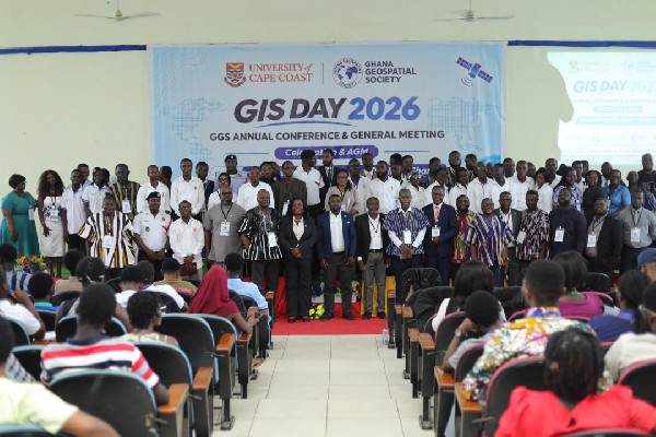
The Ghana Geospatial Society and University of Cape Coast partners called for greater investment in geospatial technology during a two-day conference held from November 18 to 19, 2026.
Professionals, academics, policymakers, students and industry players gathered at UCC for the society’s 2026 Annual Conference and General Meeting, which also marked GIS Day. Under the theme “Geospatial Intelligence for a Resilient Ghana,” they examined how maps, satellite information, drones and digital analysis can support national development, according to GhanaWeb.
Why geospatial investment matters for Ghana
Professor Kwabena Sarfo-Kantankah, Acting Provost of UCC’s College of Humanities and Legal Studies, chaired the conference. He described geospatial intelligence as essential to evidence-based decisions in urban planning, disaster management, environmental protection, agriculture and national security.
He pointed to flooding, coastal erosion, illegal mining and rapid urbanisation as problems requiring reliable spatial data. His answer was stronger cooperation among universities, government agencies and businesses, backed by information that public institutions can access and use.
That case reaches beyond technical research. A farmer can use location data to trace produce, a city assembly can map flood risks, and emergency teams can identify the fastest route to an incident. For Ghana’s entrepreneurs, these needs also open space for services in mapping, data analysis, environmental monitoring and drone operations.
GGS President Gs. Michael Nyoagbe advocated increased investment in geospatial infrastructure and public-private partnerships to support sustainable development. The message from Cape Coast was direct: Ghana needs both the equipment and the skilled people to turn spatial information into practical decisions.
A digital dashboard for Cape Coast firefighters
One of the conference’s clearest demonstrations was the handover of a digital emergency response dashboard to support the Ghana National Fire Service’s operations in Cape Coast. UCC’s Department of Geography and Regional Planning developed the tool with Youth Mappers.
The project connected university expertise with a public service facing daily operational demands. It also showed students and young professionals how their mapping work can move from a classroom exercise into an institution responsible for saving lives and property.
Professor Precious A.D. Mattah, Executive Director of the Africa Ocean Institute, delivered the keynote address. She highlighted the value of geospatial intelligence in coastal management, environmental monitoring and climate resilience, three areas with direct consequences for communities and businesses along Ghana’s coast.
Guest speaker Krijn Driessen of WaterWorX discussed international partnerships in utility mapping, drone applications and artificial intelligence. His contribution placed Ghana’s ambitions within a wider market where local teams can work with foreign partners while building technical capacity at home.
Training the next generation of GeoSpecialists
About 50 new GeoSpecialists, including lecturers and other professionals, were inducted into the Ghana Geospatial Society during the conference. Technical presentations, exhibitions and awards recognising students and staff ran alongside the induction.
Gs. Dr Julia Quaicoe, Co-Chair of the Conference Planning Committee, received a Best Lecturer Award. She led the committee with Gs. Gameli Kormla Agboada. A panel moderated by Gs. Dr Richard Adade examined spatial planning, marine conservation, environmental management and agricultural traceability.
Professor Eric Akins, Head of the Department of Geography and Regional Planning, welcomed participants and reaffirmed UCC’s commitment to geospatial education, research and innovation. Professor Rofela Combey, representing the Vice-Chancellor as Guest of Honour, stressed collaboration to make the technologies useful to students and society.
For young Ghanaians and members of the diaspora considering where their expertise can make a difference, the conference presented a growing field with public and commercial uses. Training, research partnerships and professional networks will determine how quickly that promise becomes skilled employment and locally built services.
Business support and closer work with local government
Hon. George Justice Arthur, Cape Coast Metropolitan Chief Executive and Special Guest of Honour, commended GGS for promoting geospatial innovation. He encouraged closer collaboration with the Metropolitan Assembly and expressed interest in joining the society.
Private companies also backed the meeting. MultiGeomatics Limited served as Platinum Sponsor, WaterWorX as Gold Sponsor and TGTS Africa as Silver Sponsor, with additional support from Sambus Geospatial Limited and DeMappers.
That mix of sponsors, researchers, public officials and students offers a working model for future projects. Companies gain contact with emerging talent, universities test their research against real needs, and public agencies can see tools demonstrated before committing scarce resources.
The gathering was GGS’s first annual conference outside Accra and its first collaboration with UCC’s Department of Geography and Regional Planning and the Africa Ocean Institute. An excursion to Hans Cottage Botel added networking and environmental observation to the programme.
Ghana’s wider technology push
The Cape Coast discussions fit a broader national debate about building local capacity rather than relying entirely on imported systems. At the Ghana Space Conference 2026, Deputy Minister for Communication, Digital Technology and Innovations Mohammed Adam Sukparu urged investment in domestic research, innovation and skills, MyJoyOnline reported.
“Our challenge is, therefore, not whether Ghana should invest in space technology, but how quickly and effectively we can translate that investment into tangible benefits for our people,” he said.
There is a regional opening as well. NewsDiaryOnline reported that Nigeria’s SGF and Surveyor-General urged African countries to invest in geospatial technology. Its report named Benin, Burkina Faso, Cameroon, Ghana, Mali, Niger, Nigeria and Senegal as eight member states supporting the institute through biennial recurrent budget contributions.
What participants want next
Participants closed the UCC meeting with three practical demands: stronger national spatial data infrastructure, better data sharing and greater investment in geospatial training. Those steps would address the foundations needed by public institutions, researchers and businesses alike.
The immediate test is whether the conference’s partnerships produce more working tools like the Cape Coast fire service dashboard, more trained professionals and wider access to reliable spatial information.
Frequently asked questions
What was the theme of the 2026 GGS conference?
The theme was “Geospatial Intelligence for a Resilient Ghana.” The event took place at the University of Cape Coast from November 18 to 19, 2026.
Who developed the Cape Coast emergency response dashboard?
UCC’s Department of Geography and Regional Planning and Youth Mappers developed the dashboard to support Ghana National Fire Service operations in Cape Coast.
What investments did conference participants request?
They requested stronger national spatial data infrastructure, improved data sharing and more investment in geospatial training to support Ghana’s sustainable development.